This is a compilation of learnings from the Toronto – Muskoka – Peterborough dual cross country trip that will be used as a memory jog for my first solo cross country and future cross country trips.
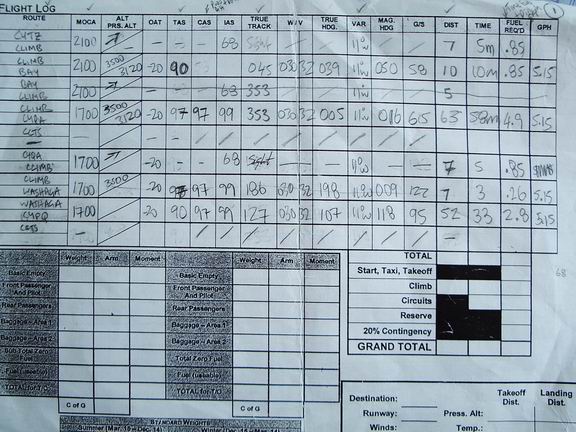
Cross country planning and preparation for your first time takes at least a couple of hours.Refer to pictures for the prepared map, flight log calculations, flight plan and weight & balance. Cross Country prepartion can be grouped into “day before” and “day of”. To summarize, on the day prior to the actual cross country, one would want to prepare the map (start, destination, way points, heading, distances, flight plan to file with Nav Canada) and on the day of, complete the flight planning with weather data (heading taking upper winds into consideration, ground speed, times to way points and destination points, pressure altitude, etc.), weight and balance and file the flight plan.
Day Before:
- Maps
- ensure that VNA/VTC maps are current (link in maps section of AIP) - POH
– ensure that it is in the plane - CFS
– ensure that you have a current CFS - Weather
– get idea of what the weather is going to be like the next day (a) on
route and (b) at destination - NOTAMs
Map Preparation
- Select
heading point (three ways – on route climb, geographic, overhead) –
geographic is preferred - Draw
lines from heading point to destination, taking into consideration terrain
features, civilization, airports on the way. - Draw
10 degree drift lines - Mark
half way points - Mark
10 mile marks - Pick
way points that are easily recognizable (and mark distance for that leg
and distance remaining)
Flight Log
- Write Routes For each leg of the route indicate:
- MOCAs
- Altitude
- True
Air Speed (from range profile from POH – based on power setting and
altitude you want to fly at – speed vs. fuel consumption) - true
track (based on center of the line from heading point to destination) - altitude
i.
above 3000 ft, fly even (if westerly) or odd (if
easterly) altitudes plus 500
ii.
base westerly or easterly on true track plus (if west)
or minus (if east) variation
- variation
- distance
- In the Enroute Observations, indicate
- Checkpoint
- Distance
- Distance
remaining
Weight and Balance
Complete all values except for landing weights (takeoff and zero fuel)
Airports procedures and airspace
Mark sections in CFS that are pertinent and review runway
configuration, MF and UNICOM procedures.
Flight Plan
With the exception of two fields (time of departure and total estimated time), the entire Canadian Flight Plan can be completed the day prior. Here are key fields and definitions:
Field 8: Flight Rules – V for VFR, Type of Flight: G for General Aviation
Field 9: Wake Turbulence category: L for light
Field 10: Equipment: VO for VOR and C for Transponder Mode C (enter VO / C)
Field 15: Cruising speed: N00XX (speed in xx), Altitude A00XX (altitude in xx’thou)
Route: D-> (for direct) “/” for stopover (and in the other information enter how long you would stopover)
Field 19: Endurance: 0530 hours from endurance profile in the POH (based on the lowest power setting. Emergency Radio: VHF and for ELT A,F) No survival equipment
Day Of:
- Call
flight service for weather briefing: 1866WXBRIEF and tell them route and
ask them for weather package - Complete
rest of flight log – for each leg: - Outside
Air Temperature (from upper winds) - W /
V (wind direction and intensity based on upper winds) - Pressure
Altitude (based on 29.92 minus altimeter pressure from METAR times 100) - Calibrated
Air Speed (from setting pressure and density on Flight Computer and
reading calibrated air speed from true air speed) - Indicated
Air Speed (from Airspeed Calibration section in the POH) - True
Heading (based on Flight Computer: (a) mark wind direction and intensity,
(b) slide to heading and set wind direction mark to true air speed, get Ground Speed from computer and determine True Heading based
on offset) - Determine
Magnetic Heading from adding (if westerly) or removing (if easterly)
variation from True Heading - Determine
Time and Distance based on Ground Speed from flight computer - Determine
Gallons Per Hour based on
Cruise Performance section of POH for the pressure altitude, power
setting and temperature - For
legs that involve climbing, look up Time, Fuel and Distance to Climb
section of the POH - Add
Distances, Times and Fuel Required. - For
Circuits, estimate based on 6 minutes at 6 GPH.(10 circuits an hour) - Indicate
Reserve based on Cruise Performance section (eg.
45% power, 3.7 GPH, so 30 minutes reserve is 1.8 Gallons.) - Indicate
20% contingency (by adding all fuel required and getting 20% of that value) - Calculate
take off distance, landing distances required for the temperature,
pressure altitude, wind) and check NOTAMS - Copy
all this data to the back of the flight Log - Finish
Weight and Balance and Flight Plan (departure time and estimated time to be
back) - Check
weather again for any changes - Ensure
plane is ready to go - File
Flight plan with 1866WXBRIEF - Organize
cockpit and GO!!
During Cross Country:
The cockpit workload when on the actual cross country for the first time is high, I suspect that it won’t seem overwhelming after you’ve done it a couple of times.
Go to set heading point
Execute SHITTTEE check
- Set
Heading Indicator (ensure you are not descending, ascending or turning) - Note
Time over set heading point - Turn
towards heading and fly (ensure heading makes sense) - Lean
mixture for peak RPM (not 50 less than because in case you forget to rich
mixture before you descend) - Set Carb heat at cardinal points
- Set
frequency and announce your intentions when entering control zones
When at Check Point
- Note
time over waypoint - Note
elapsed time (from last heading/way point) - Align
distance on the outside and time on the inside wheel of the flight
computer and write down Ground Speed - Note
estimated time to next leg and estimated time to destination in the RETA
column for the checkpoint (Note distance to next leg in the flight
computer and add the corresponding time to time over; do the same for time
to distance remaining)
Position Report:
At intervals you think it is necessary (not required for VFR flights, but this information will assist search and rescue if needed), provide VFR position report 126.7 Mhz: London Radio, London Radio, London Radio, this is XXXX over XXXX, time over XXXX, altitude XXXX, VFR
Flight Plan to destination XXXX.
Off Track:
When you are off track (based on visual), correct immediately. Using the double track
correction method:
- Revise
heading (eg. If you were off track by 5 degrees
- based on approximation with the the 10 degree
drift lines - to the port/starboard, the revised heading is 10 degrees
minus/plus heading you had intended to fly) - Fly
the heading for the amount of time you were on track last (i.e. if you
were at your checkpoint 15 minutes ago, you would fly the revised heading
for 15 minutes) - After
flying for the intended time, alter heading that is half plus/minus your
original heading (i.e. if you were originally off track by 5 degrees,
add/subtract 5 degrees to the original heading based on port/starboard
deviation)
Destination:
- Know altitude of aerodrome, circuit altitude, orientation of runways, wind
(based on departure) which will give an indication of the active runway - At time and position advised in the CFS, call UNICOM / MF to report position,
time, altitude, intentions. - For UNICOM, announce five minutes prior (“Peterborough Traffic, this is”)
- Say London Radio if MF is managed by London Radio and report call sign, wait
for response then report rest… - Plan your arrival path – Plan your descent (based on 500 ft. / min and 3500
feet, 3 minutes – at 80 ground speed this is 4 miles (using flight
computer), so start your descent accordingly - Plan your circuit joining - Overhead and join mid-downwind.
- For MF, announce when on Final
- For UNICOM, announce when overhead, announce when mid-downwind, announce when on final and announce when clear of runway
Departure:
- For UNICOM, announce “Peterborough UNICOM, this is XXXX Radio Check” and then
report intentions to “Peterborough Traffic, this is XXXX going to the
active runway for straight out departure to CYTZ” - Report when airborne “Peterborough Traffic, this is XXXX airborne and on route to
destination…” - Report when out of zone “Peterborough Traffic, this is at XXX Ft., clear of zone
and on route to destination…” - You might then have to set frequency and call air traffic control. Eg. Call